|
||||||||||||||||||||||||||||||||||
|
||||||||||||||||||||||||||||||||||


|
|||||||||||||||||||||||
 |
|||||||||||||||||||||||
| - | |||||||||||||||||||||||
|
||||
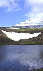
CENTRAL ARMENIA ARAGATSTOTN KOTAIK MINERALS, STONES, GEMS FLORA BIRDS OTHER FAUNA THERMAL AND MINERAL SPRINGS Aragatsotn is dominated by Mt. Aragats, the tallest mountain in the Republic. A category 1B mountain (tourist category 3) makes Mt. Aragats accessible to most mountain climbers and naturalists wanting to explore its four crowning peaks. Formed by volcanic activity, the crest is actually a rim of a massive crater which blew itself open more than 500,000 years ago, as mankind began to settle the region in earnest. The four peaks look down into the crater and to the surrounding territory. From the top of Aragats it is possible to see most of the Transcaucasus Mountain range as far as Europe's tallest mountain, Mt. Elbrus (alt. 5642m/18,506f) which straddles the Georgian and Russian border 500 kilometers to the north. To the west you have excellent views of the Ararat Valley, Mt. Ararat and Turkey, while to the Southeast lie Lake Sevan and the Karabakh Uplands. Covered with snow except for 4-6 weeks between July 15-August 15 or 30th, Mt. Aragats has two high elevation lakes, Lessing and Kara, formed from crystal clear glacial waters. Even in the heat of summer mini glaciers can be found in some lower elevation forests and alpine fields of wildflowers. For the naturalist, lower Mt. Aragats is the place to go to find wildlife and relief from the broiling summer heat. The mountain is the base for numerous dachas, pensions (a kind of summer resort popular in the former Soviet Union), camps and hiking trails. The base of the mountain is covered with canyons and rivers that run to the Ararat Valley to the West and the mountain plateau in Kotaik District to the North and East. Canyon walls plummet as much as 500 meters (984 feet), protecting a microenvironment distinct from that above. While above canyon rims meadows are bare except for rock outcroppings and a carpet of mountain grass and wild flowers, the canyon floor is covered with trees and thick bush, supporting forest animal life. The Amberd River forms one of the natural paths to the upper elevation, flowing from its source just below the top of the mountain, past a 10-13th cc fortress and summer residence for Armenia’s kings, the Byurakan observatory (the second largest n Eurasia) to the Ararat Valley floor. Wildflowers literally carpet the mountain 8 months of the year, beginning in February at the mountain base with winter crocus and anemones, continuing in seasonal bands up the mountainside through mid-August. Autumnal flowers retreat down the mountainside in Mid-August, and continue to November, when the peaks are already covered with snow. Native poppies, goldenrod, blue yellow and red straw flowers--even deep green clover cover the mountain meadows from Amberd up, making prime grazing for flocks of sheep maintained by Yesdi villagers. Yesdis are a Zoroastrian pastoral community, descendants of Kurds that refused to adopt Christianity or the Moslem faith. Most of them live along the lower sides of the mountains in Aragatsotn, Kotaik, Lori and Shirak Districts. In April and May they form an annual exodus to the upper reaches of the mountains. Along with stunning views of Ararat and Lake Sevan, you might just run across a friendly shepherd below the rim, living in a caravan style tent, tending his flock. Kotaik District is primarily a mountain steppe region, rimmed in by the Geghama Lehr on the East, Mt. Aragats on the West, and the Pambak Range on the North. The region is rocky and arid on the Southern approach from Yerevan, with wildlife and settlements hugging the Hrazdan River that cuts through the heart of the district. The Hrazdan is the second largest river in Armenia and the location where one million BCE skulls were recently uncovered. It is also a unique ecosystem like that found on the Amberd river. A natural divide between mountain ranges, the Hrazdan has carved a canyon that winds its way to the Ararat Valley floor, supporting small forests and a diversity of wildlife along the way. The contrast is most startling in the area from Bjini to Yerevan, where the drop in altitude (and temperature) from the canyon rim to the river bed is most dramatic, with multi-colored basalt, granite and tuf mountains seem to spring from the river forests. Kotaik is also home to a native forest at Tzaghkadzor, which supports forest, mountain steppe and alpine flora and fauna species, including bear, wild cat, and the red book listed Armenian gazelle and leopard. Mountain steppe wildflowers are found in abundance in Kotaik district. The best time to see them is May-July, when the spring rains and melting snows feed seas of green mountain grass that seem to cover even the rocky mountains, the grass itself covered with a patchwork quilt of lavender, yellow, orange and red flowers. Minerals, Stones, Gems Flora Lower Elevation sagebrush steppe flora includes Gladiolus atroviolaceus, Nigella oxypetala, Actynolema macrolema, Gundelia tournefort, Verbascum saccatum, Lallemanita iberica, Roemeria retracta, Scabiosa argentea, Scorronera paposa, Muscari beglecta, Stchys inflata, Astragalus distyophysus, A. kochianus, Achillea tenuifolia, Helichrysum rubicundum, Silena spergulifolia. River Gorge flora include Alkanna orientalis, Cerasus incana, Prus, salicifolia, Cerasus mahaleb, Amygdalus ferzlinia, Spirala crenata, Saxifraga cymbalaria. Geghard Gorge is particularly unique, with Linaria armeniaca, Acantholimon bracteatum, Illium akana, Tulipa julia, Corydalis augustifolius, Orni-thogalum mountanum, O. gussonei, Campanula choziatorskyi, Bellevalia longystila, Muscari neglecta, Lotus goebelia, Astragalus strictifolius, Serratula serratuloides, Tomanthea aucheri, Malus oreientalis, Prunus divaricata, Sorbus graeca, S. persica, S. aucuparia, Crataegus orientalis, C. lacimiata. Mountain Steppe flora includes Gladiolus atroviolaceus, Nigella oxypetala, Actynolema macrolema, Gundelia tournefort, Verbascum saccatum, Lallemanita iberica, Roemeria retracta, Scabiosa argentea, Scorronera paposa, Muscari beglecta, Stchys inflata, Astragalus distyophysus, A. kochianus, Achillea tenuifolia, Helichrysum rubicundum, Silena spergulifolia.
Birds Other Fauna Thermal and Mineral Springs
Climate
Change Info Center-Armenia
INDIVIDUAL REPORTS
|
| |
Search | |
||||||