Vayots Dzor
SOUTH
TourArmenia -
Overview
Vayots Dzor is bordered by the Vardenis, Zangezur and Nakhichevan Mountain Ranges, with the Vaik mountains crossing its southern area. The district’s northern border was formed by volcanoes along the Vardenis Mountain Range, the most beautiful of which is Vayots Sahr, a hangats herabukh (dormant volcano). Active in the Pleistocene era, the volcano is 2580 meters (8,463 feet) high. The crater’s diameter is 600 meters (1,968 feet) across. Descending 125 meters to the crater floor, you can sense the immense explosions that spewed fertile lava and closed off Lake Sevan from its old southern territory. Inside the crater is a 14th century stone chapel.
The district encompasses semi-desert terrain on west that rises to towering basalt, granite and tuf rock formations at the Geghama Lehr pass before tumbling into the Yelpin and Arpa river valleys. The apex of the mountain pass has a stunning view of Ararat, and a few bends in the road give ample opportunity to photograph the majestic mountain, which seems much smaller than from the Ararat valley floor. Myriad shades of red, black and chalk colored rock jut from the sides of the mountains, looking like they were dropped by spoonfuls of lava from the sky, or precision cut into quartz formations. Still other formations are reminiscent of the American Southwest, where sheer masses of rocks suddenly erupt into view, slashes of red, black and ochre in a desert landscape.
The Yelpin valley drops from the side of the highway almost half a kilometer, with “stacked rock” formations rising even with the road. The effect is like a Technicolor Chinese ink painting, where lonely pines cling to towering rocks over lush vegetation. And this is only the beginning of the district called “the jewel of Siunik” by a 10th c. royal princess. The main highway though Vayots Dzor follows the Arpa River, which itself has carved a path through otherwise impassable mountains. The Arpa supports a ribbon of green growth through the otherwise arid rocky terrain, including the vineyard region of Areni, known for the dry and semi-sweet wine which bears its name. In fact the valley produces more apricots and wild rice than grapes. The wild rice thrives along the wet marshlands, just as when it was first cultivated around 15,000 years ago.
Tributaries to the Arpa wind through spectacular rock formations and cliffs into the deep recesses of the district, where the bulk of the wildlife and early settlements can be found. Deciduous and conifer woodlands rise above the riverbeds, while the rocky cliffs support mountain scrub and pine. Above all this is a huge mountain steppe, alpine and forest ecosystem, supporting a diversity of flora and fauna second only to that in Siunik. Literally within five kilometers one passes through semi-desert, high plateau brush and mountain steppe to forests and alpine meadows. Officially in a semi-desert zone, much of Vayots Dzor is blessed with year-round precipitation so that extensive deciduous and conifer trees vie with rocky deserts for domain. Spring begins early in Vayots Dzor, with the first signs of growth beginning in the river valleys in late January, continuing through late October and early November. Winters are mild, except for the mountain peaks, which are snow-covered from late November to March.
The unique rock mountains in Vayots Dzor were formed as much by shifting tectonic plates as they were by volcanoes, the earthquakes forcing basalt, limestone, marble, obsidian and granite into tightly compacted formations throughout the district. The earthquakes also destroyed a series of settlements and royal cities, beginning with prehistoric cave settlements in the area around Yeghegnadzor through one of the most beautiful medieval cities in Armenia, Yeghegis.
 TOP TOP
Caves
Vayots Dzor is also noted for its extensive cave system, including the Archeri (Bear’s), Magili and Jerovank caverns, rated the three best in Europe by members of the French Speleological Society. Archeri and Magili are two of the largest in the Transcaucasus, and home to several rare species of fruit bat. The bats are the non blood-sucking types, and crucial to the pollination and cultivation of fruit in the region, including some of the oldest apricot plantations in Asia Minor. Archeri and Magili Caverns are home to hundreds of stalagmites and stalactites. Formed by thousands of years of calcite deposits dripping from ground water, the formations and varieties of colors are stunning, some pure white, others a translucent smoky glass, still others gold and red in color. Jerovank is the site of pagan sacrificial rites going back to the 4th millennium BCE, human and animal. The canyon outside the cave is thickly forested and a hiker’s paradise. All the caves hold a constant year-round temperature of 14 C (58 F).
TOP
Minerals, Stones, Gems
Vayots Dzor’s natural resources are relatively unexplored, though the area holds large deposits of iron, copper, silver, tin, marble, granite, tuf, perlite, basalt, andesite, obsidian, quartz, barium, sulfur, Sodium chloride, clay, aluminum ore and limestone. It is believed that Vayots Dzor was the location of gold, turquoise, diamond and lapis lazuli mines during the Bronze Age, along with other precious jewels, but if this is true, the mines have not been found in the modern age.
TOP
Flora
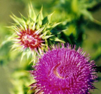
River Gorge flora include Alkanna orientalis, Cerasus incana, Prus, salicifolia, Cerasus mahaleb, Amygdalus ferzlinia, Spirala crenata, Saxifraga cymbalaria, Linaria armeniaca, Acantholimon bracteatum, Illium akana, Tulipa julia, Corydalis augustifolius, Orni-thogalum mountanum, O. gussonei, Campanula choziatorskyi, Bellevalia longystila, Muscari neglecta, Lotus goebelia, Astragalus strictifolius, Serratula serratuloides, Tomanthea aucheri, Malus oreientalis, Prunus divaricata, Sorbus graeca, S. persica, S. aucuparia, Crataegus orientalis, C. lacimiata.
Other flora include Iris lineolata, I. Caucasia, Merendera mirzoeval, Colchicum szovitsii, Gagea ssp., Puschninia scilloides, Draba ssp., Lallemantia caneseens, Ranunculur ssp., Myosotis alpestris, Pedicularis ssp., Trifolium ssp., Gladiolus kotschyanus, Silene ssp.
Noravank Canyon includes Clematis orientalis, C. vitalba, Reichardia dichotoma, Vitis sylvestris, Pistacia mutica, Noaea minuta, Mixauxsia laevigata, Leus orientalis, Serratula serratuloides, Yurinea arachnoidea, Y. pulchella, Silene megeri.
TOP
Birds
Click for Birds By Habitat: Wetlands, Mountain Steppe Wetland, Valley / Lowland, Scrub, Semi-Desert to Mountain Steppe, Mountain Steppe, Rocky Cliff / River Gorge, Mountain Slope, Upper Mountain Cliff and Gorge, Woodland / Farmland / Orchard.
TOP
Other Fauna
Primary species include caucasian goat, ram, mountain leopard (endangered species), wild bore, caucasian bear, jackal, lynx, mole, porcupine, fox, wildcat, squirrel, marten.
TOP
Thermal and Mineral Spring
Volcanic activity continues at Vayots Dzor, though it is buried far below the surface and erupts in one of the thousands of thermal springs scattered throughout the region. The largest are located at Jermuk, at the top of the Okhak Lehr Canyon, where one of two virgin forests in the district lay. The thermal springs include several types of minerals, including calcium, sodium and natural Hydrocarbonate. Other thermal springs are located near Yeghegnadzor, Noravank, Martiros and Vaik. Cold mineral and pure spring water springs are located at just about every bend in the road, river and stream, but large pools for wading or swimming can be found near Jerovank, Jermuk and Yeghegis.
TOP


LINKS
Images (photos
by Tigran Nazarian)
EcoCenter
Ecotourism.com
(currently down, but try in case)
EcoTeam
Development
Armenian Flora/Fauna Stamps
Climate
Change Info Center-Armenia
ERMC
National Academy of
Sciences of Armenia
Protected
Areas of Armenia
Map
of Sevan National Park
INDIVIDUAL REPORTS
Threatened
Species in Armenia
State
of Environment Report 2000 (UN)
 write TourArmenia -
 Top
Top

|