|
||||||||||||||||||||||||||||||||||
|
||||||||||||||||||||||||||||||||||


|
|||||||||||||||||||||||
 |
|||||||||||||||||||||||
| - | |||||||||||||||||||||||
|
||||
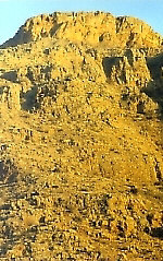
ARARAT VALLEY (+ YEREVAN) OVERVIEW IRRIGATION MINERALS, STONES, GEMS FLORA BIRDS OTHER FAUNA THERMAL and MINERAL SPRINGS Overview The rich deposits of lava that streamed into the Ararat Valley created spectacular rock formations and one of the largest deposits of tuf and basalt in Europe and Western Asia. Covering huge primordial lakes and swamps, the enriched soil ‘fermented’ over millions of years to create one of the two most fertile lands in Western Asia, the other being the land around Van in historic Armenia, present day Anatolia. As late as 1300 BCE the valleys were noted by Urartian and Assyrian chroniclers as teeming with wildlife and deciduous forests. The museums at Erebuni displays wood trestles logged in the Urartu period, while excavations at Metsamor have uncovered wooden fragments more than 6000 years old. What remains of that great valley forest now are a few woodlands along river beds, hundreds of small marshlands, semi-desert terrain on the Western and Southeastern edges and the heavily farmed valley floor. Most of the deforestation was probably complete before the rise of the Urartu Empire in the 10th century BCE and its adverse affects were recorded as early as the reign of Argishti I and King Russa, who both left behind cuneiform tablets attesting to turning “deserts into paradise” with their new irrigation systems. The same irrigation canals can be found throughout the valley around Yerevan, and modern extensions begun in the 1930’s have reclaimed much of the semi-desert areas in the Valley. Irrigation was restricted in the mid-1980's, and the area between Artik and Aruch and Southeast of Ararat City have returned to their semi-desert state. The entire valley lies between the Shirak Plateau, Mt. Aragats, the Geghama Lehr and Mt. Ararat in present day Turkey. Ararat has two peak, the larger called “Masis” (5165m/16,942f) and the smaller "Sis" (3925m/12,875f). Sis is a perfectly shaped cone, like Mt. Fuji in Japan, and together with Masis forms one of the most beautiful vistas in the world. Legends ascribe the beginning of modern mankind to Mt. Ararat, the place where Noah’s ark is recorded in the bible to have landed after the Great Flood. Though stripped of its primordial forests, Ararat Valley does have one of the largest of the nature preserves in Armenia, the Khosrov Argelots (Preserve) or Khosrov Antar (forest), named after King Khosrov II Kotaka (reigned 332-339 CE), the founder of the capital at Dvin. Khosrov ordered the planting of a forest on both sides of and running the length of the Azat River. The forest remains to this day, having grown beyond it original boundaries to encompass most of the Goghi River above Garni and Geghard, and a large area between the Azat, Khosrov, Mankuk and Vedi Rivers on the eastern side of Ararat District. Ararat Valley has extensive water resources that continue to support large wetland areas. Marshlands can be found by Masis, Metsamor, Artashat and Ararat City, home to a diverse waterfowl population, including storks, cranes, seagulls and Dalmatian pelicans. Much of the water has been shepherded into ponds and lakes for breeding fish, which has encouraged additional diversity in water flora and fauna. Several varieties of reeds, water lilies and ferns thrive in these marshland areas, which themselves are surrounded by cultivated land or semi-desert terrain. Irrigation Minerals, Stones, Gems Flora Birds Other Fauna Thermal and Mineral Springs
Climate
Change Info Center-Armenia
INDIVIDUAL REPORTS
|
| |
Search | |
||||||